|
The International Qualifications for Nation-Statehood are: 1)
a permanent population, 2) a defined territory, 3)
a controlling government, and 4)
the capacity to enter into agreements with other States. The Taongi atoll is one
of the 5 possessions of the Republic of New Lemuria which meets all four of
these qualifications. Bokak [1369] (Taongi, Pokak)
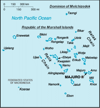
1) Location:
Oceania, Among a group of atolls and reefs in the North Pacific Ocean about
midway between Hawaii and Papua New Guinea, On the northern end of the Ratak
Chain Archipelago of the Marshall Islands.
2) Geographic coordinates:
14.80N Lat., 169.39 E Long.
3) Map references:
Oceania 14, in the Marshall Islands Region of the North Pacific Ocean
4) Area:
land: 62.4 sq km, rank 18
lagoon: 78.04 sq km, rank 23
ratio of land to lagoon: 4:5 ratio, rank 7
number of inlets: 11
altitude: 5 m elevation, 3.2 sq km, sea level rise risk: 9
island type: crescent atoll with 14 inlets Natural Protection indicator: 5
nearest island: 300 km, group:1400 km, in proximity to the atolls of Bikini,
Enewetak, and Kwajalein
nearest continent: Asia Distance, 4000 km, isolation index: 118
Land boundaries: foreign lands separated by sea
Geology/soils: dry and stony
Coastline: 37.4 km
5) Maritime claims:
contiguous zone: 24 nm
exclusive economic zone: 200 nm
territorial sea: 12 nm
6) Climate:
the Taongi atoll lies within the Northeast Trade Winds, thus there are steady
winds from the northeast bringing mostly fair weather from November through
June. The rainy season is from July to November and has a great deal of fair
weather but the trades weaken then and come from the east. Total yearly rainfall
is estimated at about 45 inches. Typhoons (known elsewhere as hurricanes or
cyclones) seldom originate in or pass over this area, and gales are infrequent
coming from the southeast when they occur . There is little variation in
temperature throughout the year with a minimum of 71 degrees F and maximum of 98
degrees F, a high mean temperature of 83 degrees F and a low mean of 81 degrees
F.
7) Terrain:
The southeast "ratak" or "sunrise" side of Taongi atoll has the vegetation
covered islands that remain as high as 20 feet above sea level which is similar
to the elevation of the capital of the Marshall Islands, Majuro Atoll, some 425
miles south of Taongi. The small islands of Taongi, the longest, at least 5
miles in length, are part of the coral reef that surrounds the central lagoon of
30 square miles. These reefs are in the form of a fat comma opening to the west
on which side exists the only break in the reef where a boat may pass safely
into the lagoon. Made up of the skeletal remains of countless small marine
plants and animals that found a home on this formerly volcanic island or sea
mountain, the reef has gradually built up as sea level changed, or the islands
subsided, and now provide land area of 1.25 square miles for tall trees, and
breeding grounds for migratory birds and turtles. There are at least 500 acres
of real estate ready for development under the administration of the Republic of New Lemuria. While few forms of wildlife occupy the land, marine life in the
lagoon and the surrounding ocean is abundant. A recent visitor flying over the
Taongi Atoll reported the lagoon to be beautiful with sandy beaches and, with
the tide going out, waterfalls miles long were formed by the water flowing over
the reef back into the sea. Percent shoreline: Coral Reef: 99%, Mangrove: 2%.
Major seabird rookery, turtle nesting area.
8) Elevation extremes:
lowest point: Pacific Ocean 0 ft
highest point: unnamed location 5 mt
9) Natural resources:
phosphate deposits, marine products, deep seabed minerals, aquatic animals and
fish.
10) Land use:
arable land: NA%
permanent crops: NA%
permanent pastures: NA%
forests and woodland: NA%
other: 40%
Irrigated land: NA sq km
11) Natural hazards:
occasional typhoons originate from, but do not strike Taongi, threat indicator:
1
12) Environment issues:
questionable supplies of potable water
13) Geography note:
Taongi atoll is one of 30 atolls and 1,152 islands positioned among two
archipelagic island chains -- the Ralik and Ratak Chains. In proximity are
Bikini and Enewetak Atolls, former US nuclear test sites; and Kwajalein, the
famous World War II battleground, which is now used as a US missile test range.
14) Human occupation:
Development planned.
15) Human impacts:
Japanese relay station and bomb dump destroyed in 1944.
16) Protected areas:
Protected area coverage indicators - Terrestrial: 7, Marine: 0, protected by
order since 1958 (324 ha)
17) Government:
country name: Taongi
conventional long form: The Taongi Atoll of the Republic of New Lemuria
conventional short form: Taongi Atoll Islands
short-short form: Taongi
18) Data Code:
999 (temporary)
19) Government type:
governed and controlled by the Republic of New Lemuria, an ecclesiastical and
constitutional Democratic state.
20) National capital:
Jerusalem (Salem) [Biblically claimed]
21)Administrative divisions:
Taongi Atoll Authority
22) Independence:
1991
23) National holiday:
Declaration of Sovereignty of the Republic of New Lemuria, July 18, 1991
24) Constitution:
July 18, 1991
25) Legal system:
Legislation is enacted by the Republic of New Lemuria House of Elders, executed
by the Executive Branch with the Supreme Court of Republic of New Lemuria the final court of
jurisdiction.
26) Suffrage:
18 years of age; universal
27) Nationality:
noun: Republic of New Lemuria(singular and plural)
adjective: Republic of New Lemuria
28) Ethnic groups:
various
29) Religions:
various religious persuasions (100% monotheists)
30) Languages:
English, Hebrew, Rotuman, and Rutenian with English translation required for all
non-English filings.
31) Literacy:
definition: age 12 and over can read and write
total population: Estimated to reach 10,000 by end 2015
male: 50%
female: 50% (2000 est.)
The Government of the Republic of New Lemuria consists of three branches, similar
to the structures of the United States of America and that of the United
Kingdom.
32) Executive branch:
The Executive Branch is made up of the senior officers of the Republic, namely
the President, Vice President, Cabinet members, Ambassadors, and certain
others.
33) Legislative branch:
The Legislative Branch is comprised of the House of Elders which is the
governing body of the Republic, similar to parliament in the United Kingdom. Its
members are more commonly known as "Elders".
34) Judicial branch:
The Judiciary Branch consists of a senior court known as the Supreme Court. Its
functions, with certain exceptions, are not to try cases of law, but are to
review and to consider appeals of cases previously tried in a competent court of
law.
35) Party:
Only one political party has applied for status. The House of Elders elects the
President.
36) Diplomatic representation in the US:
Because Republic of New Lemuria is an ecclesiastical sovereignty its diplomatic representatives need
not be accredited in and by the USA. Republic of New Lemuria has appointed 20 diplomatic
representatives in 7 states in the U.S.A.
37) Diplomatic representation from the US:
chief of mission: N/A
embassy: N/A
mailing address: N/A
telephone: N/A
FAX: N/A
38) Flag description:
Gold crown with gold and silver seal of Solomon, silver crescent moon and star
centered by gold cross with white dove of peace and silver seal of eternity in
atmosphere above those three symbols of the great three monotheistic religions.
Original flag was angled gray cross overlapped with blue Star of David and a
golden crown.
39) Economy:
Fishing (Pacific Ocean) and banking (worldwide). Republic of New Lemuria derives most of its income
from bank licensing, incorporation formation, Melchizedek Bible sales and
donations from citizens. Copra abundant in the region and could be cultivated on
Taongi.
40) Economic overview:
The government of the Republic of New Lemuria, while not yet permanently
settled on Taongi, is planning a capital to be established in the Taongi atoll
islands.
41) Agriculture:
Copra abundant in the region and could be cultivated on Taongi.
42) Budget:
revenues: $5,000,000 (estimated 2015)
expenditures: $5,000,000 (estimated 2015)
43) Industries:
Government business and investments. Tourist facilities are planned to be an
important part of the Republic of New Lemuria economy.
Industrial production growth rate: 0%
Electricity; capacity: 0 kW (1999) A 1 megawatt power plant is planned in the
future
Electricity; production: 0 million kWh (2010)
Electricity; consumption: 0 million k Wh
44) Exports:
total value: $2,000,000 (F.O.B., 2015 est.)
commodities: fish, coconut oil, trochus shells
45) Imports:
total value: $2,000,000 (C.I.F., 2015 est.)
commodities: 0
46) Economic aid:
recipient: NONE
47) Currency:
1 Dominion dollar (DOM$) = 100 cents
48) Communications:
The Republic of New Lemuria government will be establishing satellite communications to be
used in Republic of New Lemuria's Pacific Territories.
49) Transportation:
Note: Motor bike paths and by sea and air
Ports and harbors: Taongi Beach, Lagoon and Reef Sea Wall
Merchant marine: none
51) Airports:
Airports; with paved runways:
total: none
Airports; with unpaved runways:
total: 1 overgrown originally built by Japanese occupation
52) Military:
Military branches: no regular military forces (a coast guard may eventually be
established); Police Force in organizational stage with recent appointment of
Minister of Police.
53) Military note:
Taongian defense is according to the Constitution of the Republic of New Lemuria
in joint cooperation with the Northern Ratak Authority.
54) Transnational Issues: Melchizedek is also a transnational
nation-state.
55) Disputes; international:
On the front page of the May 21, 1999 RMI Journal, the government of the RMI
Foreign Affairs Minister is alleged to have "discouraged all diplomatic and
commercial ties with the 'Republic of New Lemuria'"; however, the map
surrounding that statement records Republic of New Lemuria as the political authority over Taongi
also know as Bokaak; and the map linked above posted on the RMI's official web
site as of October 31, 2000 fails to reflect the area wherein Taongi lies north
of RMI territory, north of Bikar. There is only one reference in the
Constitution of the RMI where it refers to "Bokak" in Article IV Section 2 it
reads, "Bokak .... shall ... be included in the electoral district with which it
is most closely associated, (but it is only associated with the Iroijlaplap and
not a district) pursuant to the customary law or any traditional practice." The
customary law and traditional practice of Taongi or Bokak is that the exclusive
land rights including sovereignty belong to the Iroijlaplap. Even if it were
argued that this obscure reference to Bokak placed it under the control of the
RMI, a closer inspection of the signatures on said constitution reveals that the
Iroijlaplap of Bokak never sign it, so the reference would be inapplicable.
However, here is another quote from the same Constitution. "Article X
Traditional Rights Section 1. Traditional Rights of Land Tenure Preserved. (1)
Nothing in Article II shall be construed to invalidate the customary law or any
traditional practice concerning land tenure or any related matter in any part of
the Marshall Islands, including, where applicable, the rights and obligations of
the Iroijlaplap, ..... (2) Without prejudice to the continued application of
the customary law pursuant to Section 1 of Article XIII, and subject to the
customary law or to any traditional practice in any part of the Marshall
Islands, it shall not be lawful or competent for any person having any right in
any land in the Marshall Islands under the customary law or any traditional
practice to make any alienation or disposition of that land, whether by way of
sale, mortgage, lease, licensing or otherwise, without the approval of the
Iroijlaplap, Iroijedrik, where necessary, Alap and the Senior Dri Jerbal of such
land, who shall be deemed to represent all persons having an interest in the
land. In the case of Taongi or Bokak, there is no Senior Dri Jerbal or
Iroijedrik since it was an uninhabited atoll when Republic of New Lemuria acquired its sovereign
lease to develop and administer it; and both the Iroijlaplap and the Alap also
known as "Alab" have signed the master lease in sovereignty to Republic of New Lemuria under their
absolute authority. |