Introduction.
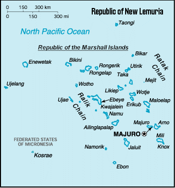
 Taongi
is located at 14.38 north latitude and 168.58 east longitude lying within
the Northeast Trades, thus there are steady winds from the northeast bringing
mostly fair weather from November through June. The rainy season is from
July to November and has a great deal of fair weather but the trades weaken
and come from the east. Total yearly rainfall is estimated at about 45
inches. Typhoons (known elsewhere as hurricanes or cyclones) selNLBA originate
in or pass over this area and gales are infrequent coming from the southeast
when they occur. There is little variation in temperature throughout the
year with a minimum of 71 degrees F and maximum of 98 degrees F, a high
mean temperature of 83 degrees F and a low mean of 81 degrees F. Taongi
is located at 14.38 north latitude and 168.58 east longitude lying within
the Northeast Trades, thus there are steady winds from the northeast bringing
mostly fair weather from November through June. The rainy season is from
July to November and has a great deal of fair weather but the trades weaken
and come from the east. Total yearly rainfall is estimated at about 45
inches. Typhoons (known elsewhere as hurricanes or cyclones) selNLBA originate
in or pass over this area and gales are infrequent coming from the southeast
when they occur. There is little variation in temperature throughout the
year with a minimum of 71 degrees F and maximum of 98 degrees F, a high
mean temperature of 83 degrees F and a low mean of 81 degrees F.
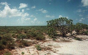
The
southeast "ratak" or sunrise side of Taongi Atoll has the vegetation covered
islands that remain as high as 20 feet above sea level which is two times
the elevation of the capital of the Marshall Islands, Majuro Atoll, some
425 miles south of Taongi. The small islands of Taongi, the longest, at
least 5 miles in length, are part of the coral reef that surrounds the
central lagoon of 30 square miles.
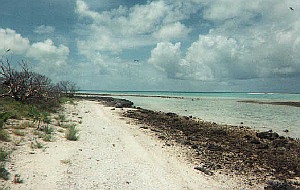
These
reefs are in the form of a fat comma opening to the west on which side
exists the only break in the reef where a boat may pass safely into the
lagoon. Made up of the skeletal remains of countless small marine plants
and animals that found a home on this formerly volcanic island or sea mountain,
the reef has gradually built up as sea level changed, or the islands subsided,
and now provide land area of 1.25 square miles for tall trees and breeding
grounds for migratory birds and turtles.
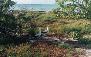
While
few forms of wildlife occupy the land, marine
life in the lagoon and the surrounding ocean are abundant. The lagoon
to be beautiful with sandy beaches and, with the tide going out, waterfalls
miles long were formed by the water flowing over the reef. The beach pictured
to the right is typical of those on the lagoon side of the Taongi Islands.
There
are at least 500 acres of real estate ready for development under the administration
of the Republic of New Lemuria.
|